GOVERNMENT PROJECTS
|
SEC has had the opportunity to complete a variety of projects for local municipalities, counties, state and federal agencies. Government work includes a wide variety of projects from large, county-wide wildfire protection plans to street reconstruction and utility line extensions. These projects call for specialties in forestry and natural resource management, GIS, engineering, surveying, public participation coordination and master-planning.
|
|
Government Project Examples
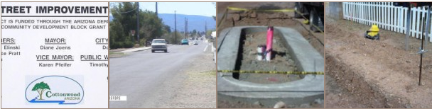
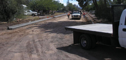
12th Street Improvements: The Twelfth Street neighborhood is an older area located within the City of Cottonwood. The current street needed to be improved to adequately provide access to the existing homes on either side of the street. This project redesigned a 3,000 foot stretch of Twelfth Street, incorporating drainage and street design requirements while maintaining appropriate consideration of the surrounding neighbors and existing conditions. The City of Cottonwood retained SEC to lead and complete this project which is funded by a Community Development Block Grant from the Department of Housing and Urban Development. As a requirement of this grant, the design and construction were required to be completed on an accelerated timeframe. SEC took this project as an opportunity to fine tune internal project management in addition to the engineering design and community involvement requirements.
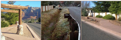
Jordan Road Sedona: This project included work on the historical trail and road in Uptown Sedona. The road needs to support local and tourist traffic on the minor collector classification. The street section of the project was revised to include area drainage and the addition of a sidewalk, curb and gutter. The sidewalk design had to incorporate ADA requirements as well as event pedestrian traffic. Multiple designs were required along with extensive public input and coordination which included conflict resolution and design compromise for driveway location, parking opportunities and signage. SEC was also able to incorporate landscape areas within the design. SEC also incorporated bid documents and coordination with the City for contract clarification, request for information and contractor selection.
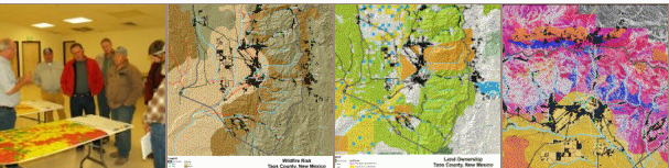
Taos County CWPP: The Taos County Community Wildfire Protection Plan (CWPP) was developed collaboratively by local and state government representatives using periodic core team meetings to provide input and to review plan preparation progress. General public meetings were conducted throughout the county to determine community values. Utilizing data from a variety of sources, the process of identifying the at risk areas was achieved through a series of maps, which displayed different intensity levels for the components that constitute wildfire hazard and risk. The different intensity levels were assigned a numerical value and resulted in a threat level ranking from extreme to low. The extreme and high threat levels when combined with community values produced a risk assessment that identified the wildland urban interface surrounding the county communities. Communications and education are essential to community involvement and adopting defensible space concepts, regulations and codes. The New Mexico Forestry Division and local fire districts were key organizations in implementing the resulting recommendations.
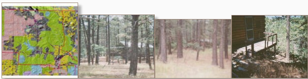
Rio Arriba CWPP: Working collaboratively with local and state government representatives, fire districts, Federal agencies and interested parties, this landscape scale Community Wildfire Protection Plan (CWPP) was developed to produce a risk assessment for community protection. The process of identifying the areas at risk was accomplished through the development of a series of maps, which displayed different intensity levels for the components that constitute hazard and risk. The extreme and high threat levels then were combined with community values determined from local participation to produce a risk assessment that identified the wildland-urban interface surrounding the communities. Communication and education were the key to community involvement. This kind of community wildfire protection planning relies heavily on the use of defensible space concepts to reduce the risk of losing structures to fire. Effective use of limited resources required coordination between land management agencies, community interests and local plan administrators. The results of such coordination among agencies and communities allowed the CWPP to become a dynamic document to guide the needed action steps to achieve community protection.
Rio Arriba County Wildland Urban Interface (WUI): The Rio Arriba County WUI plan was developed by the multi-disciplinary SEC team to provide the county with a program-based method of meeting the goals of community wildfire protection over a 10-year planning horizon. Goals included the management of forest fuels to protect life and property and promote forest restoration along with securing the funding to “jump start” management implementation. Other major goals included marketing resultant wood products to sustain landscape scale treatments and adopting an emergency evacuation plan. Community values were also factored into the planning process. The action steps presented as a result of this planning process included community outreach and education, innovative structural and policy approaches, formation of collaborative groups and relationships to create opportunities for project implementation and economic development. Forests needed to be treated using restoration techniques and financial resources/funding needs were identified, Restoration by-product utilization strategies were developed on the local and regional level.
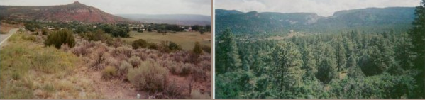
Dry Beaver Creek Floodplain Study: The purpose of this project was to restudy the final 5 miles of the Dry Beaver Creek watershed before its confluence with Wet Beaver Creek. The intent of the analysis was to provide a hydraulic analysis of sufficient detail to allow revision of the FEMA Flood Insurance Rate Map. Dry Beaver Creek was modeled using the Army Corps of Engineers HEC-RAS and HEC-HMS software and attempted to accommodate the increased development in the area. After the completion and approval of the detailed study, SEC was retained by Yavapai County to make the necessary submittals to amend the FEMA Flood Insurance Maps. Detailed field reconnaissance was conducted for data collection, as well as coordination, communication and research to comply with FEMA standards. Tasks included project scheduling, meeting coordination, field surveys, hydrologic analyses, hydraulic analysis, floodplain mapping, and preparation of a technical data notebook in accordance with state and federal standards. Extensive public participation was required in order to collect local resident flood experience data.